InfoRange


Rangeland-based livestock production is a major land use system that contributes between 15 and 60 percent to the agricultural GDP of countries in eastern and southern Africa. This type of production uses very little external inputs that draw on fossil fuel resources, but requires a great deal of knowledge and information.
DITSL - German Institute for Tropical and Subtropical Agriculture and Transdisciplinary and Social-ecological Landuse Research
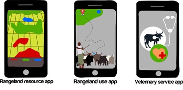
The InfoRange project starts here and uses digitisation to make mobile pasture-based livestock husbandry more efficient, developing ICT solutions together with user groups – i.e., livestock keepers and herders as well as veterinarians, among others. This involves bringing together diverse stakeholders’ knowledge to work out what digital solutions for better pasture management and veterinary care might look like and what is needed for successful use of the ICT solutions. Similar to the geotagging of photos and of live traffic reports, user-generated information will be uploaded into a mobile phone application. This will then be combined with remotely sensed data. Through image processing and machine learning, the visual rangeland scoring will be digitalised and the output fed to mobile phone applications as well as availed for scenario analyses.
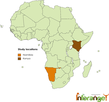
In Kenya and Namibia, InfoRange brings multiple stakeholders together from each study area to involve them in decision-making and transdisciplinary knowledge integration. Getting this participation from the beginning improves the relevance of results for local communities and increases possibilities for impacting policy decisions.
Zakieh Alizadehsani, Oliver Hensel, Abozar Nasirahmadi (2025). Multiscale transformer-based network for rangeland plant classification used in pasture scoring. Smart Agricultural Technology, Vol 12, https://doi.org/10.1016/j.atech.2025.101183
Sentamu DN, Arasio RL, Akala H, Makau DN, Wasonga OV and Onono JO. 2024. Stakeholder analysis and their roles in livestock disease reporting and response in Northern Kenya. Pastoralism: Research, Policy and Practice 14:13468. doi:10.3389/past.2024.13468
Wako, Malit., Scheiterle, Lilli. & Kaufmann, Brigitte. 2025. Harnessing local knowledge: Analysis of rangeland governance among the Borana and Rendile pastoral communities in Northern Kenya. IASC 2025 – XX Biennial Conference of the International Association for the Study of the Commons, June 16–20, 2025, University of Massachusetts Amherst, USA.
Keerthana Sri, Maria Restrepo, Margareta Lelea, Lilli Scheiterle, Brigitte Kaufmann. 2025. What information is relevant to pastoral women related to milk management? Tropentag 2025 (hybrid), September 10–12, 2025, Bonn, Germany.
Sebastian Schmidt, Oliver Hensel, Abozar Nasirahmadi. 2025. Monitoring of pastoral landuse systems in East African rangelands using GPS data and a hidden Markov model. Tropentag 2025 (hybrid), September 10–12, 2025, Bonn, Germany.
Maria J Restrepo, Felista Timado, Raphael Gudere, Mpule Kamwi, Mareike Aufderheide-Voigts, Hussein Wario, Brigitte Kaufmann. 2025. Making room for feedback: Operationalising transdisciplinary research with pastoralist communities in Kenya and Namibia. Tropentag 2025 (hybrid), September 10–12, 2025, Bonn, Germany.
Mareike Aufderheide-Voigts, Mpule Kamwi, Rufo Roba Halakhe, Maria J Restrepo, Brigitte Kaufmann. 2025. Enhancing livestock husbandry and rural livelihoods through peer-to-peer information access: A transdisciplinary approach in communal areas of Namibia. Tropentag 2025 (hybrid), September 10–12, 2025, Bonn, Germany.
Haron Akala, Raphael Lotira Arasio, Maria J Restrepo, Brigitte Kaufmann, Oliver Wasonga. 2025. How herders use vegetation thresholds to guide herding decisions among Rendille pastoralists in northern Kenya. Tropentag 2025 (hybrid), September 10–12, 2025, Bonn, Germany.
Halkano Galma Bonaya, Lilli Scheiterle, Oliver Wasonga, Brigitte Kaufmann. 2025. Evolving information needs for rangeland resource management among Borana and Rendille pastoralists in northern Kenya. Tropentag 2025 (hybrid), September 10–12, 2025, Bonn, Germany.
Derrick N. Sentamu, Raphael Lotira Arasio, Dennis N. Makau, Joshua Orungo Onono. 2025. Pastoralists’ preferences during livestock disease reporting and response in northern Kenya: A participatory study. Tropentag 2025 (hybrid), September 10–12, 2025, Bonn, Germany.
Tresia Ipangelwa, Mareike Aufderheide- Voigts, Morgan Hauptfleisch, Mpule Kamwi, Lilli Scheiterle, Brigitte Kaufmann. 2025. Changing grounds: Community perspectives on rangeland governance and livestock management in eastern Namibia. Tropentag 2025 (hybrid), September 10–12, 2025, Bonn, Germany.
Rufo Halakhe, Maria J Restrepo, Brigitte Kaufmann. 2025. Peer-assisted smartphone learning to support digital literacy and participatory design in northern Kenya. Tropentag 2025 (hybrid), September 10–12, 2025, Bonn, Germany.
Malit Y. Wako, Lilli Scheiterle, Hussein Wario, Brigitte Kaufmann. 2025. Evolving resource governance in pastoralist societies: The enduring power of elders despite emerging institutions in northern Kenya. Tropentag 2025 (hybrid), September 10–12, 2025, Bonn, Germany.
Rangeland-based livestock production is a major land use system that contributes between 15 and 60 percent of the agricultural GDP in eastern and southern African countries. The growth of rangeland vegetation is highly variable in space and time, occurring in temporary patches.
Knowledge of rangelands is crucial to their management and strategic use of resources. Local communities have developed strategies that are grounded in cultural practices, stories, ethics, and norms specific to their area. These strategies also require access to up-to-date information on heterogenous and seasonal resource availability.
However, site-specific information on the condition and intensity of use of rangeland resources is rarely available or accessible to herders in real-time. Consequently, incomplete or outdated information is often the basis on which pastoralists make decisions.
Information and communication technologies (ICT) have considerable potential to provide easily accessible up-to-date information to increase efficiency based on spatial data generation, telemetry services, GPS navigation services, and mobile phone network services, reliably facilitated by an ever-growing system of private and public satellites.
To successfully co-develop technology, InfoRange uses a transdisciplinary approach to create the ICT solutions together with users in a way that embeds them in social innovations. Through an actor- and activity-oriented approach, we build on the knowledge of different involved actor groups to understand how their decision-making can be improved through ICT.
Linking digital solutions to the existing system offers opportunities for the community to improve their information gathering and sharing and make it more effective. In addition, digitization can facilitate communication between various stakeholders, such as veterinarians, authorities regulating water supply in pasture areas, or government agencies involved in other pastoral services.
InfoRange‘s goal is to improving rangeland use and governance and increasing resource-use and production efficiency in rangeland-based livestock production through digital and ICT applications/services that permit user-generated information acquisition and transmission.
InfoRange uses a social-ecological systems approach to:
Adapt, modify and further develop existing ICT tools for decision support in rangeland management and use as well as for veterinary service provision.
Render digital and ICT services more relevant for rangeland users’ immediate management decisions (e.g. on grazing, watering and health management) and overall rangeland governance.
Develop procedures and solutions to enhance the use of ICT tools by land-users and increase their distribution and accessibility under reduced network coverage
Integrate external telemetry and observatory data with land-user-generated data of bio-geo-physical ecosystem features and applications/services that permit user-generated information acquisition and transmission.
The project will be implemented in Kenya and Namibia. In Kenya, the project will be implemented in the northern arid and semi-arid Marsabit County in Laisamis and Moyale Subcounties – i.e. two study locations. In Namibia, InfoRange will be implemented in the Kavango East Region (including George Mukoya and Muduva Nyangana Conservancies) and Omaheke Region (including the Eiseb Conservancy and Aminuis).
InfoRange seeks to contribute to integrating external telemetry and observatory data with land-user generated data on bio-geo-physical ecosystem features in order to render digital and ICT services more relevant for land-users’ immediate management decisions on grazing, watering and animal health management.
Objective 1: Understand the current system used by pastoralists to collect and share information relevant for decision-making on resource use, its shortcomings and the information needs of communities.
Objective 2: Based on this needs assessment, the objective is to adapt, modify and develop existing ICT tools to support rangeland management and use decisions and veterinary services.
Objective 3: To make digital and ICT services more relevant to rangeland users by developing methods and solutions to enhance the use of ICT tools and increase their distribution and accessibility under reduced network coverage.
Objective 4: To combine approaches from citizen science, crowd data sourcing, machine learning and participatory monitoring and evaluation to make ICT tools more relevant for decision making at different levels of governance.
Perceptions of rangelands vary widely, depending on the value we place on what we see, and what is worth knowing, sharing, and protecting. Furthermore, the discipline, scale, and methods of data collection and analysis change what is seen. To address the needs of pastoral communities, their values, needs, and requests must be integrated into the research process.
The overall approach of the project is to understand, recognize and value the current system of information gathering and sharing in pastoral production and rangeland use, and to identify effective ways of complementing it, rather than introducing a new system that may prove disconnected from the current practice.
InfoRange puts the potential users at the center of a research endeavor to increase their respective benefits from increasing resource use and production efficiency in rangeland-based livestock systems. Therefore, building on pastoralists’ current system of collecting and sharing relevant information for decision-making on resource use, InfoRange will employ a transdisciplinary approach to co-design ICT solutions with users and embed them in social innovation.
InfoRange will combine user-generated information (e.g. similar to geotagging photos in google maps or live traffic updates) with remotely sensed data. State-of-the-art machine learning models will be developed to analyze the generated crowd data (e.g. time series), capture and understand phenomena such as differences in pasture use intensity as well as classify and recognize patterns in different scenarios.
Including representatives of different governance bodies from the onset of the project permits the creation of outputs in formats suitable to enhance policy decisions. Leaving the ownership of the information collecting and sharing system with the local actors will result in the wide use of the newly introduced tools beyond the project end.
